Unionville Loop Tour
(2 hours, 50 miles)

(2 hours, 50 miles)
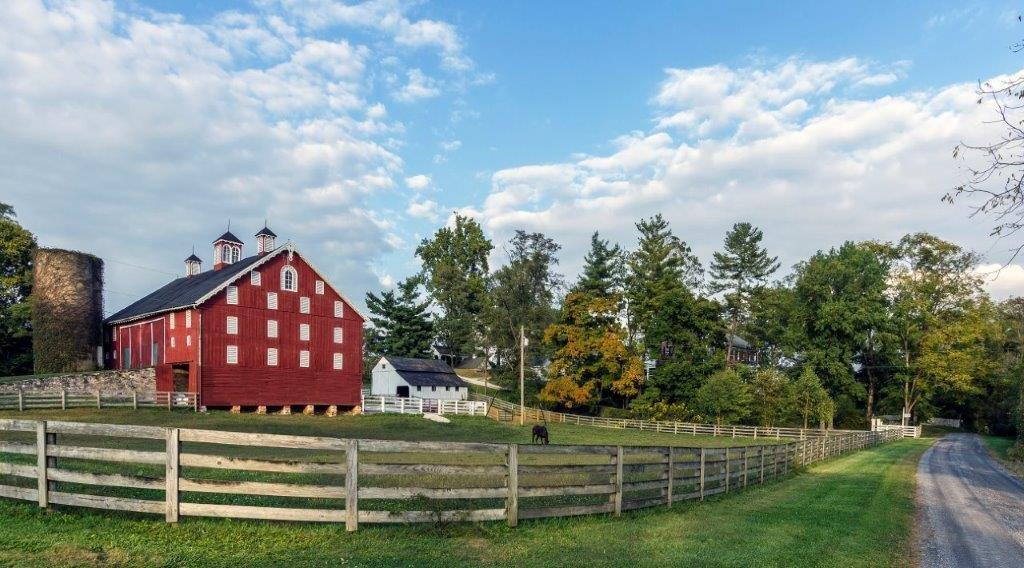
Tour #3 in Eastern Frederick County takes you through beautiful farmland from Mt. Airy on the eastern edge of the county, west to Johnsville, and then south to Walkersville. The tour starts at the Historic B & O Railroad Station, 1 North Main Street, Mt. Airy, MD and ends at the Walkersville Southern Railroad – both significant transportation providers for travelers, industries, and farmers in the region.

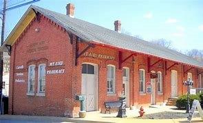
1. The B & O Railroad Station in Mt. Airy is near the intersection of Center St. and N. Main Streets. It is now the Mt. Airy Pharmacy. As you drive into Mt. Airy from Rte. 27/Main Street, look for the Train Depot (now a hobby store) on your right. Turn right into the train station parking lot at that corner, and go around the station (now a pharmacy). Mt. Airy was a railroad town from the 1830’s when the Baltimore & Ohio Railroad built a spur to facilitate getting over the mountains. The tracks were finally removed in the 1970’s. The railroad’s history in Mt. Airy is complicated, but if you wish to pursue it, visit the Caboose Visitor Center across the street.
Turn right (north) out of the train station parking lot onto N. Main Street, past several large Victorian houses on your right. Go around the curve and pass the Church of the Messiah on your left. Continue around the curve about 200 feet to the next left turn, which is not well marked. This is Buffalo Road.
2. Bear left onto Buffalo Road, leaving town and enjoying the rolling farmland. Pass Old Bohn Rd. and Shirley Bohn Rd. on your left and continue another 3 miles to Black Ankle Rd. Just FYI, buffalo did exist in Maryland, but were basically extinct here by the time of the American Revolution. The road was more likely named as part of an 1826 movement to build a road from Washington, DC to Buffalo, NY to facilitate movement of trade and troops to Canada.
Watch for a long white fence on your right and a brown sign for the Talbot Run Equestrian Center. The next road on your left is Black Ankle Rd.
3. Turn left onto Black Ankle Rd. Black Ankle Rd becomes a gravel road. Enjoy a good example of a nice tree canopy as you climb the hill. Drive 2.0 miles to a stop sign which is the intersection of Black Ankle and Black Ankle (!!).
4. Turn right to stay on Black Ankle Rd. At 1.0 mile on left is Black Ankle Vineyard, a family- owned local winery. Reservations are required for tastings, but they do serve some snacks and local dairy products if you need a break.
Drive another 0.6 miles to the stop sign at Unionville Rd. Unionville was a crossroads village which grew up around the 1840’s at the intersection of Unionville and Clemsonville roads and included a blacksmith, wheelwright, tavern, and harness maker.
5. Turn left onto Unionville Road. Drive just 0.3 miles to Albaugh Rd. on the right. (The cream- colored farm complex on your left, just before you turn, is Sunset Ridge Farm where they board and train horses.)
6. Turn right onto Albaugh Rd., a gravel road. Drive 0.5 mile to stop sign at Liberty Rd. (SR 26). Cross Liberty Rd to continue on Albaugh Rd. Within 100’, the road makes a sharp right – do not enter the two private lanes at that corner! Albaugh Rd becomes gravel again at this point for 0.6 miles, and is a “roller coaster road.” Drive slowly! You will come to a sharp left turn and on your left at 9084 Albaugh Rd. is a lane leading back to the Pearre-Metcalf House. It is a Greek Revival style farmhouse built of brick about 1859. On the opposite side of the road, at 9085, is the Pearre-Ensor Farm, an agricultural complex with a brick and stone house from about 1875. In the 1880s the Wrightsville Iron Ore Co. mined a section of the Ensor property and shipped the ore to Pennsylvania.
Continue to the stop sign at New Windsor Rd. (SR 31).
7. Turn left onto New Windsor Road (SR 31). Drive just 0.3 miles to McKinstry’s Mill Rd.
8. Turn right onto McKinstry’s Mill Road. Drive about 3 miles, winding through open farmland.
Watch for the lane on the right with two brick pillars at 10735 McKinstry’s Mill Rd. Slow down, and watch for a small Restricted (one-lane) bridge. Cross the creek on this bridge. Then as you carefully drive through a grove of trees, you will come to an old wooden mill on your right, as the road turns to the right. You want to turn left here onto Pearre Rd.
This mill is McKinstry’s Grist Mill, which was the center of a small community in Carroll County in the mid-1800’s. The drive-through at the end of the mill is unique in Maryland and one of only a handful in the entire U.S.
9. Turn left onto Pearre Rd. The road immediately crosses Sam’s Creek via a Warren Truss bridge, built in 1908. About 1 mile along the road, as you come up the hill and the gravel surface ends, there is a small cemetery on the left that served the entire community. About 0.4 mile farther along on the left at 14121 Pearre Rd. is the Clemson Farm, which consists of a brick house, stone and frame smokehouse, and several other buildings. The Clemsons came to the colonies from England in the late 1600’s and migrated to Maryland from Lancaster, PA.
Across the road, at 14122 you will pass the Hopewell historic farm complex. The Pearres came to Maryland from Scotland in 1719 and gradually moved west to Frederick County, marrying into the Clemson family. The large brick house, on your right, was built by the Clemsons and is still occupied by the Pearre family, eight generations later. The property includes the brick house, a stone dairy, as well as other outbuildings and tenant houses. For many years, the gardens on the property were well known, and acres were dedicated to a bird sanctuary. The farms are leased out now, but are still active.
Drive to stop sign at Clemsonville Rd.
10. Turn left onto Clemsonville Rd. Drive 0.2 miles to a stop sign at Fountain School Road. The white house on the corner used to be a general store and the Clemsonville post office.
11. Turn left to stay on Clemsonville Rd. The first house that you will see on your right, sitting back from the road, is “Bear Garden.” This stone house was built circa 1770 by the Sweadner family. After several sharp turns in the road, there will be a large house with pillars and a red roof on the slope to your right (10120 Clemsonville Rd.) This is the Clemsonville Manor House, or “Clemmont,” now the home of the Clemsonville Christmas Tree Farm. It was built by John Clemson, a farmer who owned much of the land here in the late 1700’s.
Drive 0.5 mile to the stop sign at New Windsor Rd. (SR 31).
12. Turn right on New Windsor Rd. (SR 31). Drive 1.5 mile to Coppermine Rd.
13. Turn right onto Coppermine Rd. About 0.5 mile from the intersection, Keys Chapel Rd. is on the right. The former Keys Chapel Methodist Episcopal Church is just down this road, along with Keys Chapel Cemetery at the end. It is believed the Chapel was named for the Rev. John Key (1832-1901) who is buried there. The church would have been part of an old black community called Oldfield, where formerly enslaved Blacks first purchased land in the 1850’s in what became a significant small rural Black community where the Oldfield Colored School was located.
Drive about 2 miles to Bessie Clemson Rd.
14. Turn right onto Bessie Clemson Rd. Watch for the Triple J Farm on your left. At the next driveway, there is a pond. Behind the pond and the trees, is a house named “Strawberry Summit” where Bessie Clemson (1888-1988) lived. The house was built in 1872 by her father. Bessie was one of the earliest women to drive a car in the community and the first woman to own a car. She traveled widely around the US, she had a great sense of humor, a joie de vivre, and she made the most of that car!
Drive about 1.8 miles to the stop sign at Fountain School Rd.
15. Turn left onto Fountain School Rd. Drive about 0.75 mile to Molasses Road.
16. Turn right onto Molasses Road. Drive 0.2 miles to Repp Rd. on the right.
17. Turn right onto Repp Rd. The Christian Repp Farmstead, dating back to 1853 was in the open area to your right, and is still owned by his descendants. Drive 1.5 miles to the stop sign at Green Valley Road (SR 75).
18. Turn left onto Green Valley Rd. (SR 75). Drive 0.7 miles, and watch for an overhead sign about Reduced Speed. Turn left here onto Dotterer Rd.
19. Turn left onto Dotterer Rd. Drive 0.6 miles to stop sign at Molasses Rd.
20. Turn right, back onto Molasses Road. The first farm on your left is owned by the Dotterer family which has been in the area since the early 1800’s. Drive about 0.75 mile 12529 Molasses Rd., on your left. This was the Kitterman-Buckley farm, established by a German immigrant in 1752. (Sorry to say you can’t see the house.) Note the Johnsville Auction house which next on your left – an interesting place to watch for estate sales. Drive to the stop sign at Green Valley Rd (SR 75).
21. Turn left onto Green Valley Road (SR 75). This stretch of SR 75 was known as Johnsville, which was settled by English and German immigrants in the 1740s. In the early 19th century, it became a stoppingplacefortravelersbetweensouthernPennsylvaniaandFrederick. Drivejust0.3milesto Renner Road. At the intersection, there several white buildings with red metal rooves.
22. Turn right onto Renner Road. Drive 0.7 miles to a sharp right bend in the road. GO STRAIGHT AHEAD!! Do not turn with the road. You are now on Whiskey Springs Rd.
23. Follow Whiskey Springs Rd., a gravel road, for 1.5 miles. You will eventually pass Etzler Mill Rd. The Etzler family owned several saw and grist mills in the area. They organized the Glade Valley Milling Co., and later merged with the Walkersville Elevator Co. Go to the stop sign at Coppermine Rd.
24. Turn right onto Coppermine Rd. This intersection is the Centerville Survey District, a group of 10 houses which are the remains of a small community that developed in the 1850s. Several of the homes are original log cabins, now covered by siding. There were copper mines in Maryland from the time of the American Revolution. The most notable was probably the Dolly Hyde Mine near Libertytown.
On your left, watch for the Grace Lutheran Church at Rocky Hill. Turn into the driveway and cruise past the extensive cemetery with many old Frederick names on the stones. This is one of the oldest and most historic Lutheran congregations in Frederick County. The current building was erected in 1889, although the original church was built in the mid 1700’s.
Drive 2.5 miles to the traffic signal at Woodsboro Pike (SR 194.)
Woodsboro was named for Joseph Wood of Israel Creek, who leased the land from Daniel Dulaney. His son organized the town, which became a market town and popular stagecoach stopover. In 1873, the Pennsylvania Railroad built a line from the York, PA area to Frederick and built a small station in Woodsboro, bringing with it many small businesses.
25. Turn left onto MD Route 194 south. Drive for 3.1 miles to Walkersville. Walkersville was originally a market town on the roads to Frederick and Annapolis. When the railroads arrived in the 19th century, the town continued to grow and thrive.
Pass the traffic light at Devilbiss Bridge Rd. As you come to the traffic light at Glade Blvd., get in the right-hand lane to go straight through the intersection.
26. Keep right when the road forks, going onto East Frederick Street in Walkersville. Drive two blocks, passing the small post office on the right. Watch for the old Marsala’s Restaurant on the right.
27. Turn right on Main St. at Marsala’s. Continue to the first stop sign.
28. Turn left onto Pennsylvania Avenue and go 0.5 miles to the railroad tracks
29. Pull into the parking lot on the right. The Pennsylvania Railroad Frederick Secondary line was built just after the Civil War and eventually ran from Columbia, PA through York, Hanover, Taneytown, Keymar, and Woodsboro into Walkersville and Frederick. It was heavily used to carry farm produce to market as well as a passenger service. In 1972, Hurricane Agnes flooded Frederick and destroyed the bridge over the Monocacy, severing the railroad between Walkersville and Frederick. The State of Maryland purchased the property but did nothing with it for 20 years.
In 1993 the State finally cleared the line of brush and debris and contracted with the Walkersville Southern Railroad, a tourist railroad, who repaired the Monocacy bridge so that limited service could begin. There are now weekend train rides in restored cars. Check their website for special events.
END OF TOUR
If you wish to go north toward Thurmont,
1. Continue west on Pennsylvania Ave, which becomes Biggs Ford Rd., and intersects with Rte. 15 north.
If you wish to go south toward Frederick,
1. Go back along Pennsylvania Ave. the way you came, to the stop sign at Main St.
2. Turn right onto Main St. and continue to the second stop sign.
3. Turn right onto MD 194 for 1.5 miles toward MD Route 26. On your left as you approach this intersection, you can see the Ceresville Mansion, a modern day wedding venue, and the old Ceresville Mill facing MD Route 26. This water-powered mill was built about 1813 on the site of an older mill. Waterpower was supplemented by steam in 1850 and electricity in the 1890s. Its flour was sold under the “Snow Drift” and “Pure Gold” brand names. The mill was closed in 1988.
4. Continue on MD 194 past the traffic light at Monocacy Blvd. Ahead of you are large overhead signs directing you to Route 15, where you can go south or north.


