The Sugarloaf Area Tour
40 miles, approximately 2 Hours

40 miles, approximately 2 Hours
The Sugarloaf Area spans the southern part of Frederick County – to the C&O Canal, and around Sugarloaf Mountain Park. The Livable Frederick Master Plan (2019) and the Sugarloaf Treasured Landscape Management Plan (2021) focused on protecting the natural beauty of this portion of Frederick County. The area is also full of historic sites, wooded lanes, and beautiful farmland
1. From the Frederick Visitors Center, turn Right (South) onto East Street for 1 mile. (We recommend driving in the left lane.) Go around the traffic circle, straight through the traffic light Monocacy Blvd., then straight across the I-70/40 overpass, following signs for 85 South. Go straight through the traffic light at Francis Scott Key Pkwy. There is a traffic light at SR 355, where you will continue to go straight.
2. East Street has become SR 85 (Buckeystown Pike). Pass the Walmart and Guilford Drive on your right, then a light at Grove Rd. and then the AAA Travel Center, also on the right. As you pass the Francis Scott Key Mall on your left, follow the overhead signs to stay on SR 85, passing under I-270. Pass the Toyota and Honda dealers on your left, and the Westview Shopping Center on your right. Go straight at the traffic light at Executive Way. Pass Marcie’s Choice Lane, (which is the location of the Frederick County Detention Center) on your left.
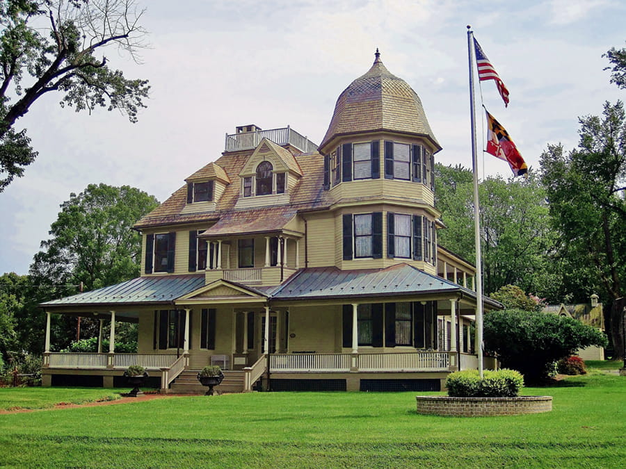
Note the large white house with a cupola on the right. This is the Arcadia House, a 45-room mansion that was built in 1801 by the owner of the Antietam Iron Works. Both Union and Confederate generals used it as headquarters, and Confederate wounded were housed there during the Battle of the Monocacy.
Continue past the traffic light at English Muffin Way. There used to be a large lime kiln operation built in 1858 by Manassas J. Grove in this area, but the remains of the kiln were demolished some years ago. A rich limestone fault runs under Frederick County, and is partly responsible for the county’s productive farmland. Lime is used for fertilizer, and for road surfacing when mixed with sand. In the late 1870’s Mr. Grove built a toll road from Frederick to Buckeystown, using the lime from these kilns. However, by 1912, the lime deposits in this area were exhausted and the local industry ended.
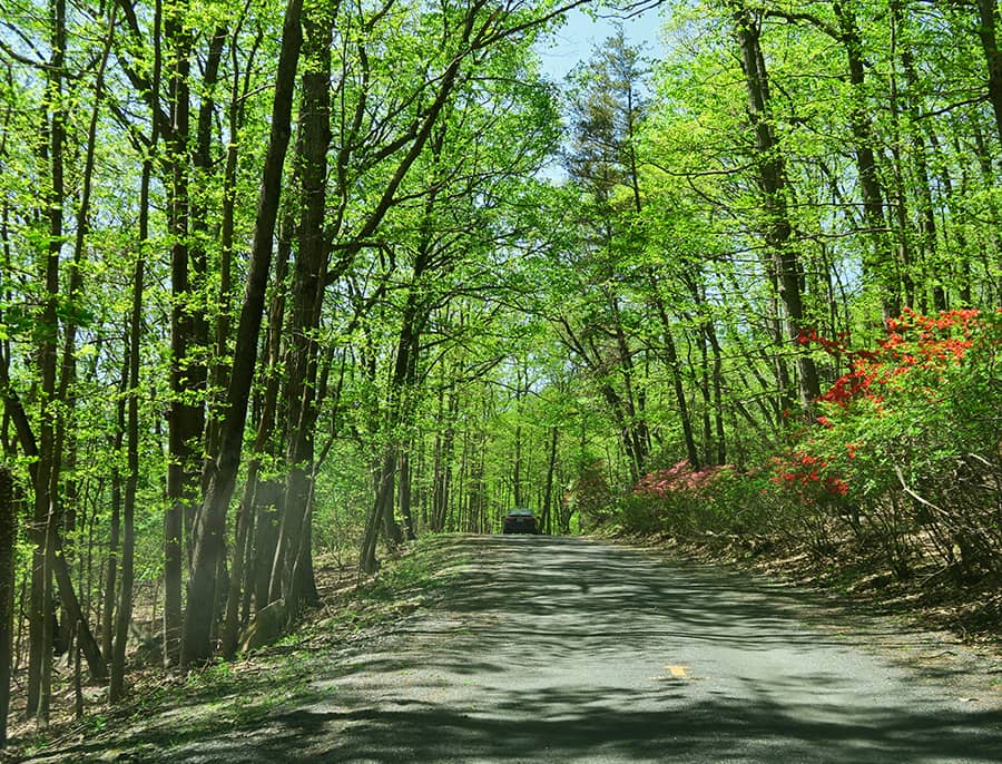
Drive about 3 miles south toward Buckeystown. And prepare to SLOW DOWN!!
As you pass Hedgeapple Angus Farms on the left, note that the speed limit drops to 30 mph. Buckeystown is diligent in issuing speeding tickets, so mind the sign!! Buckeystown was the site of a tannery owned by John and George Buckey during the American Revolution. Take time to admire the beautiful old Victorian and Queen Anne homes along the road. The town also boasted a brickworks and a cannery. Most of the workers were housed along Michaels Mill Rd. and Buckingham Lane, which formed a mostly black community at the time.
As you leave Buckeystown, you will see Mayne’s Tree Farm on the right, a popular place for picking fruit and pumpkins, and cutting your own Christmas tree.
About .5 mile past the intersection with SR 80 (Fingerboard Rd.), you will see a sign on the left for the Clagett Center, a working farm owned by the Episcopal Diocese of Maryland and named for the first Episcopal bishop of Maryland. In 1898, this was the Buckingham Industrial School for Boys, but it is now a conference center and camp for special children.
Keep driving south on SR 85, about 6 miles, passing Lilypons Rd./Oland Rd., and then Thanksgiving Farm Nursery. Lilypons Rd. is the home of Lilypons Water Gardens, a company that has supplied plants and fish for water gardeners since 1917. Or, you can simply wander around the gardens enjoying their peaceful setting.
Watch for the intersection with SR 28 West.
3. Turn right onto SR 28 (Tuscarora Rd) toward Point of Rocks. Drive only about .5 mile, just past the little Tuscarora post office on your left.
4. When SR 28 bears right, go straight onto Noland Rd. (It looks like a driveway between Chick Rd and SR 28. There is an old gray/green farmhouse on your right as you enter the road.) Noland Rd. is completely gravel.
5. At the stop sign, turn Left onto New Design Rd. Drive .3 miles to the C&O Canal parking lot, going under the railroad bridge. This is the Noland’s Ferry segment of the C&O Canal Historical Park. According to the Canal Trust, Philip Noland took over ferry operations here in about 1754, and it became a relatively busy hub. It is the site of several Revolutionary War crossings – used by both the colonists and the British. It was used by the Quakers, Swiss, Germans, Dutch, Swedes and others who were moving south from Pennsylvania. The ferry site included a country store, wagon shop, shoemaker, tailor and blacksmith shop. The Licksville slave market, which catered to buyers from the deep south, was also located nearby. There are now picnic areas, a boat ramp, and hiking trails. Turn around in their parking lot (where there is a public toilet, if needed) and leave the park.
6. Follow New Design Rd back under the railroad bridge. Look for the second right turn. (Do NOT turn onto Nolands Ferry Rd.!)
7. Turn right back onto Nolands Rd. Follow this the short distance back to SR 28 (Tuscarora Rd.)
8. At the stop sign go straight across onto SR 28 (Tuscarora Rd.) Pass the little Post Office now on your right.
9. At the next stop sign, turn left back onto SR 85 west (Buckeystown Pike) toward Frederick.
10. Drive about 1.5 miles to Greenfield Rd., which is just past Thanksgiving Farm on the right, an independently owned nursery and farm market, and the Mad Science Brewery. The hops for the beer are grown right there on the farm!
11. Turn Right onto Greenfield Rd. Follow the road several miles past the farms and down the very long hill. As you get to the bottom of the hill, you can see the Monocacy River through the trees on your left. The Monocacy is the largest Maryland tributary to the Potomac, and flows from southern Pennsylvania to join the Potomac in Montgomery County, MD. At 2.1 miles, as you leave the river, there is a sharp right jog in the road and it becomes paved. You will begin to go uphill again, past large open farms on your right. Watch for a long white fence on the right, then look for Page Rd. on the left. The road sign is hard to see. (If you come to a stop sign on Greenfield Rd., you have passed the turn for Page Rd. Turn around and go back!)
12. Turn left onto Page Rd. (a gravel road) for .2 miles to Park Mills Rd. There is a stop sign here.
13. Turn left onto Park Mills Rd. About .5 mile along, you will cross a wide concrete bridge over the Monocacy River. As you go up the hill from the river, you pass Loch Moy Farms, an equestrian center where the Maryland Horse Trials are held. Farther along, at 1646 Park Mills Rd, on the left, is the former Koontz United Methodist Chapel (now a private home) and cemetery. The chapel was built in 1893. In another mile or so, you will again pass Lilypons Rd., on the left. After passing several large farms, you will come to a concrete bridge over Bennett Creek, after which you immediately need to turn right.
14. Turn right onto Bear Branch Rd for one block. This is a narrow residential road that takes you over to Mt. Ephraim Rd. On both sides of the road, there was the Amelung/Kohlenberg Glassworks in the late 1700s. Two of the existing buildings were general stores in the past, when the area was part of a busy milling district.
15. Turn Right onto Mt. Ephraim Rd. This very long and forested drive goes south through Sugarloaf Mountain Park and through the Stronghold Estate. Gordon Strong was a Chicago lawyer who saw Sugarloaf Mountain on a trip to Washington and decided to purchase 2000 acres around the area for a retirement retreat. Stronghold became a sort of private community with schools for local children. He built a vocational school there for indigent boys from Chicago. Strong set up a trust fund in 1947 that maintains a trail system and other tourist facilities at Sugarloaf Mountain. The mountain and its immediate environs continue to be open to the public, but they are privately owned by Stronghold, Incorporated. You will see spots by the road where you can park your vehicle and get out to ride or walk on trails.
During the Maryland Campaign of the American Civil War in 1862, Union forces occupying the summit, which was being used as an observation and signal station, first spotted the Army of Northern Virginia on September 5 as it crossed the Potomac River into Maryland.
President Franklin D. Roosevelt, briefly considered using Sugarloaf as his Presidential retreat, but he was persuaded by Strong to choose the nearby Shang-Ri-La site on the Catoctin Mountain, which today is known as Camp David.
Eventually, you will come to wide open residential lots on your right, and in the midst of these are an old white frame church called Bells Methodist Episcopal Chapel, and the Comstock School. This area was part of a black community that goes back to at least the Civil War. By the early 1900’s, when these structures were built, most of the residents were black workers on the Gordon Strong estate.
After the chapel and the school, the road returns to the forest. A little farther on, watch for Banner Rd., coming into Mt. Ephraim from the right. Just beyond Banner Rd, you will come to a fork.
16. Bear left at the fork onto Comus Rd. On your left you will pass the entrance to the Strong Mansion. Continue straight on Comus Rd. to the stop sign and large plaza intersection at the entrance to Sugarloaf Mt. Park. The low building on the right was Gordon Strong’s vocational school for boys.
17. Bear Left across the plaza (keep the little white house on your right) onto Sugarloaf Mountain Rd. This road travels up the eastern edge of the Park. Eventually on your right, you will see wide open farmland that is owned by Aschenbach Farm where they raise angus beef cattle. Continue for 2.5 miles to a split in the road, with a pair of Stop signs. Drive straight, toward the left-hand sign.
18. Turn Left onto Thurston Rd. Pass Slate Quarry Rd. on the right, then cross a concrete bridge over Little Bennett Creek, and watch for a modern log cabin house on your left. This is Covell Rd. and there is a small pony truss bridge over the creek. Drive another 1.7 miles to Peters Rd. When you see an open field on the left, get ready to turn left. Thurston Rd. continues around a right curve, but you want to make a sharp left onto Peters Rd. This is almost a U-turn, so be careful of oncoming traffic!
19. Turn Left onto Peters Rd. for about 2 miles. In the late 1700’s, the Bloomsbury Forge was located at 8401 Peters Rd., which is the large property with a wooden fence and a private drive straight ahead of you. This was an iron finishing manufactory owned by Roger Johnson, brother of Thomas Johnson, first governor of Maryland in the 1770’s. It is one of several forges run by the four Johnson brothers, who initially established the Catoctin Iron Furnace up in Thurmont. You will pass a private community (an entrance with stone walls) called Greer’s Landing on your left. Drive carefully on the narrow, gravel road while you enjoy a clear view of Bennett Creek for about 1 mile. Watch for the intersection with Roderick Road, which will fork away to the right.
20. Turn right onto Roderick Rd. The first part of the road is gravel, but becomes paved. Several historical properties are located on this road. At 2700 is the George Kanode Farmstead (now the Urbana Riding Club). At 2914, the Bar-T Mountainside Camp occupies the Murdock Lawson Farmstead. The Samuel Schwartz Farmstead is located at 2923, and the George W. Horman House can be found at 3302. All are currently occupied, and have been enlarged and renovated over the last few decades. The Murdock-Lawson and the Schwartz houses date back to the 1800’s, and the Murdocks also had a sawmill on the property. The Horman and Kanode homes were built in the 20th century, but include original outbuildings such as barns, a meat house, well house, and a brick dairy. The latter building, on the Horman farm was used as the processing and bottling plant for the Tip Top Dairy from 1925 to 1940.
Follow Roderick Rd. north for 1.9 miles to the stop sign at the end.
21. Turn Right on SR 80 East (Fingerboard Rd). Watch for a yellow sign indicating a fork in the road. Follow the road to the left – do not go straight. Go around the traffic circle and continue on SR 80. Follow the signs for Rte. 270 north toward Frederick or south toward Rockville.